Saturday, August 14, 2010

Day Hike - West Marin - Bass Lake - 8/14/2010

Bass Lake Hike Map - Click to Enlarge


Sarah and I were attending a friends wedding in Bolinas. Because Sarah was a bridesmaid, I had a couple of hours of free time while she got ready with the wedding party.
I drove less then ten minutes from the wedding location before pulling into the dirt parking lot at the Palomarin Trailhead. Over the years this trailhead has become increasingly popular as there were already about a hundred cars in the lot. The weather was foggy but not too cold. I set off along the Coastal Trail which passes through a forest of Eucalyptus and over a wooden bridge before jaunting out toward the coast. A solitary picnic table is set beside the trail offering the first views of the ocean.

View from Picnic Table -Click image to Enlarge-

For the next ½ mile or so the trail hugs the edge of the bluffs above the coastline without much change in elevation.

Easy Walking


The distant Farallon Islands were in clear view today.

Farallon Islands

Because I was crunched for time I decided to pick up the pace and jog certain segments passing several groups of hikers along the way. There were quite a few folks with camping gear heading out to Wildcat Camp for an overnight.
The trail soon veers Northeast as it climbs moderately uphill. The trail opens up offering a view of the section of trail I just hiked.
Previous trail segment

A variety of wildflowers dotted the trailside.

Bull Thistle

Sticky Monkey Flower

Indian Paintbrush

Cow Parsnip

Northern Yarrow ?


A small blue fluttering butterfly landed for a moment and I managed to capture a picture.
Acmon Blue

After topping out, the trail heads slightly downhill to a signed junction with Lake Ranch Trail.
Trail Junction

I kept left toward Bass Lake and Wildcat Camp.
The surrounding area soon became very lush and green.
Lush Segment

I passed two spur trails leading to small ponds which I would check out on the way back. A little bit further lead me to an overlook of Bass Lake.
Bass Lake Panorama -Click Image to Enlarge-

Bass Lake Overlook

I could hear people swimming in the lake and soon spotted several people near the rope swing. Although shore access is difficult around Bass Lake, it is great for swimming. Just be careful of the vast amounts of poison oak lining the spur trails. I had made it to Bass Lake in 50 minutes, which left me a little over an hour to get back in time for the wedding. There would be no swimming for me today. I snapped a few more photos and started the hike back.
Bass Lake & Morning Glory?

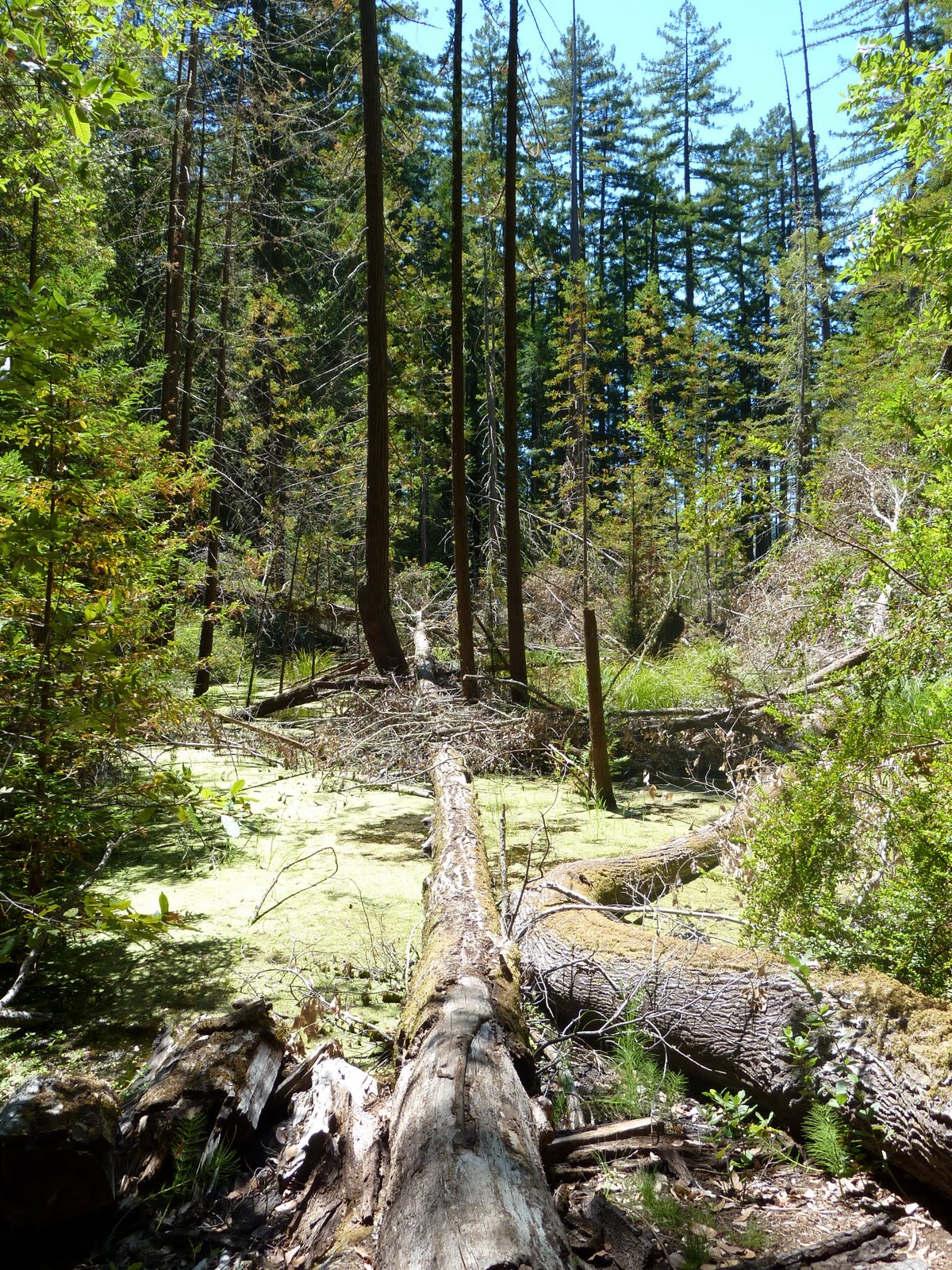
Within a few hundred yards I took a short spur trail to the right leading to a small pond where I sat and had lunch. The ponds surface was covered in a green moss type algae.
Lunch at the Pond -Click Image to Enlarge-

I had the pond to myself but could hear people walking by on the nearby trail. After a quick bite to eat I continued onward to the next pond which was much nicer in retrospect.
Spur Trail to Pond

Another Pond

This pond was half covered by giant lily pads and offered a much better environment for a lunch break.
Lily Pads

Although I did not see any, I’m told there are snapping turtles in this pond.
I continued moving at a fast pace and soon made it back to the top of the bluffs passing another 25 people heading in the opposite direction. A small patch of blue sky appeared for the first time in these parts in months. The fog continued to give way to bright and sunny skies. The colors displayed in front of me were truly incredible.
First Sign of Sun all Summer

Natures Beauty
The ocean went from intense blue underneath the patch of clear sky to a dull silvery gray further out beneath the bank of fog.
Color Contrast

The camera does no justice here.
A short ways further brought me back to my car and the end of my hike.
© copyright 2010

Monday, August 2, 2010

Day Hike - Marin - Cataract Falls , Alpine Lake Loop - 8/1/10

We parked our car just beyond Alpine Dam at the trailhead for Cataract Falls. The trailhead is normally full of cars, however, we were lucky enough to pull right up and find a spot.
We set off up the Cataract Trail. Although this time of year the water is but a trickle, it was still visually stimulating. The trail starts off skirting the side of Alpine Lake. Although boats are not allowed on the lake we did see a pair of MMWD rangers zoom by us in a powerboat.
MMWD rangers hard at work!

What a fun job that would be! After less than a half mile along the lakeshore the climbing begins in earnest. The trail leads away from the lake and up Cataract Creek. The trail is steep with wooden stairs and many switchbacks. The creek is full of cascading waterfalls and small wading pools, great for a hot summer day.

Small Waterfall


Cascading Cataract Creek


Wildflowers were not prevalent on this hike, however, we did run into this Foxglove on the side of the trail.

Foxglove


Another half mile or so uphill brought us to a junction with the Helen Markt trail which we would be returning on. We continued on the Cataract Trail. From here it levels out a bit still staying close to the creek offering views of the fern filled streambed.
Soon thereafter we were visited by an owl. It landed on a branch above us and stared for a while.
Great Horned Owl


View of owl from below

We hung out underneath it for about ten minutes before it flew away.
We continued on up the trail as it continued climbing. We soon came to another trail junction where we took a left onto High Marsh Trail.
The trail veers eastward away from Cataract Creek and onto a grassy, sunny hillside offering some of the best views of the hike.
(click on image to enlarge)

We could see Bolinas Ridge extending out to Olema with views of Tomales Bay as well as the golden hills of West Marin. The trail continues past a signed junction with Bare Knoll trail (which leads to Laurel Dell Fire Rd.) just before heading back into the shaded forest.
At the junction with Bare Knoll

The majority of the hike save for the grassy knoll and a few other patches would be in the shade. For most of the High Marsh Trail the elevation falls and rises frequently, quite steeply at times. We passed another unsigned spur trail on our right leading to Laurel Dell Fire Rd. followed later by Old Stove Trail also leading to the fire rd..
One of the few sunny patches

We crossed the W. Fork of the Swede George Creek which was dry at the surface at this time. We continued onward past the junction with Music Stand Trail across the Swede George Creek and then took a left on Willow Trail.
Lush ferns beside the trail

We then walked by the “High Marsh” which was pretty much dry and then stopped for lunch at the “Willow Meadow” along the E. Fork of Swede George Creek. In my many trips on this trail I have yet to see the East Fork dry up, and today was no exception. There was a healthy flow of running water which made for a nice setting.
E. Fork Swede George Creek


After lunch we continued along Willow Trail to the junction with Kent and Stocking Trails. We opted not to check out “Hidden Lake” which is just a short distance further down Stocking Trail. I’ve seen it plenty of times before and we figured it would be but a mud puddle. Instead, we took a left onto Kent Trail which is a straight shot down to the shore of Alpine Lake. Along the way we passed "Foul Pool" which was covered in pretty green lily pads and algae.
Foul Pool

The trail down is steep most of the way with some filtered views of the lake below.
Once at the shoreline we took a break on the rocky beach which had great views of the lake.
(Click to enlarge image)

Alpine Lake with start of Pine Mtn. in the background

We sat and watched several osprey diving for fish, none with any luck. Interesting bright red Dragonflies were flying in abundance along the shoreline.
Red Dragonfly

From our break at the shoreline we moved onward along the Helen Markt Trail toward Cataract Creek. We soon crossed Swede George Creek which was flowing gently. We’ve been here in the winter and its been roaring! Although still very enjoyable, the trail then unfortunately leads uphill and away from the lake. It climbs quite a bit before leveling off.
At the very beginning of our hike we had heard noisy bird calls in the distance which sounded like babies. It is now that we heard those noises again. Only this time they were much closer. We then spotted a giant osprey nest full of babies. The mother soon landed on a perch nearby.
Mother Osprey on perch with baby poking its head out of the nest

We sat and watched contently as the babies squawked.
Close up of the mother


The "fierce look"


Spread Eagle....or "Spread Osprey"!

Unfortunately the mosquitoes had started swarming and without any repellant were forced to move on.
Just a few steps further down the trail Sarahs’ knee gave out. She put on a brace with hopes of it helping with no avail. We soon came to the junction with Cataract Trail where we rested by a small cascade trickling into a good sized pool.
Small waterfall at junction of Cataract and Helen Markt

A great pool to cool off in on a hot summer day

Sarah was in a great deal of pain and she suffered greatly down the last mile or so which consisted of mainly steep stairs. I did the best I could to help her down the stairs. At the bottom of the trail near the lake I noticed a very interesting plant that we missed on the beginnnig of the hike.
Red Clintonia

We eventually made it back to the car and quickly drove back home to ice Sarahs' knee.
© copyright 2010