Monday, September 19, 2011

Castle Lake to Heart Lake Hike - Day 8 - Trip Report - 9-17-11

          We woke up at dawn and stepped out onto the catwalk of the Girard Ridge Fire Lookout where we had spent a very quiet night. There was a hint of color above Castle Crags and we enjoyed some tea as the morning grew brighter.

First Light on Castle Crags


Girard Ridge Lookout

          After breakfast we loaded our daypacks and drove down the ridge to I5 where we headed north toward the city of Mt. Shasta. We exited off of I5 and headed west toward Lake Siskiyou but veered left onto Castle Lake Road before reaching the turnoff for Siskiyou Resort. Several miles later we pulled into the Castle Lake parking lot which was full and booming with activity. The vicinity is very popular with dispersed camping and therefore receives a fair amount of transient traffic. There was a large group of about 30 young folks camped out and I assumed they were all homeless travelers as their hygiene was virtually nonexistent; but my assumptions were disproved as we watched several of them fetch some items from their shiny new cars in the lot. Go Figure!
          Castle Lake is set in a large cirque with tall cliffs making up the southern headwall and steep hillsides to the east and west. There are plenty of camping spots on the north side of the lake where the hiking trail begins.

Map of our Heart Lake Hike Route

          We set off from the parking lot and followed the trail around the northwest shore where we started climbing up the ridge toward the southern headwall. Near the top of the ridge there is a saddle where there are several faint use trails that lead in the direction of Heart Lake. If you reach a seasonal pond you’ve missed the turnoff.
          The trail, which is occasionally hard to follow, maneuvers over rocky terrain as well as through meadow grass and wildflowers. Having previously studied the topo map we just kept heading in the direction that felt right to us (toward the top of the southern headwall) and soon found ourselves looking over the shallow and small Heart Lake. For this reason it is known to be a good swimming lake, warmer than the average mountain pool.
          We sat at the edge of the lake on a large boulder and enjoyed it to ourselves. I ventured around the shore to the south end to get the quintessential view of Mt.Shasta reflected in the water.

Mt. Shasta Reflected in Heart Lake


Heart Lake


Heart Lake Reflections

          While relaxing at Heart Lake we noticed a use trail that followed the edge of the headwall overlooking Castle Lake up to a steep cliffside overlook. We traversed along the cliffs edge stopping frequently to absorb the vast scenery that included Castle Lake shimmering below with Mt. Shasta and Black Butte dominating the back drop.

Views From the Headwall

          After some steep climbing we made it to the craggy overlook which precariously overhangs over the edge.

Craggy Overlook


Castle Lake Overlook

          We had a snack and took it all in for a while. From where we sat we noticed a steep ridgeline and what looked like a faint trail leading up to the top of peak 6617’. Looking at the map and the terrain in front of us, we judged that once we reached the top, we could traverse the ridge east and then descend to reconnect with the trail to Heart Lake making a short but strenuous loop.
          Despite the fact that the use trail up the steep ridge line appeared to be laden with shrubs, it was a clear path for the most part. As we grunted up the challenging ridge, we could see Heart Lake below starting to fill up with a cluster of the transients and a couple of determined folks following in our footsteps toward the rocky overlook.

Looking Down on Heart and Castle Lakes

          We reached the top which earned us views of the north side of Castle Crags, a perspective that was new to us both. To the west was Mt. Eddy with its colorful scree mountainside. There was a nice outcropping at the top which was decorated with rock stacks and other rock drawings.

Castle Crags from Peak 6617'

          After another long break we headed cross country along the ridge through more pilings of stacked rocks.

Good Times!


Castle Crags

          We picked up a faint path and continued traversing and descending until we eventually picked up the trail to Heart Lake. From there we contemplated going to see Little Castle lake which lies just below the saddle to the east. We made it as far as a seasonal pond which was dry at the moment before retreating down the official trail back to Castle Lake. The cross country travel up along the ridges was difficult footing and took its toll on the knees.
          We made it back to Castle Lake where we found a nice spot along the north shore to hang out for a while. We waded in the cool water to sooth our aching knees. We planned on diving in but a cold wind picked up and we chickened out.
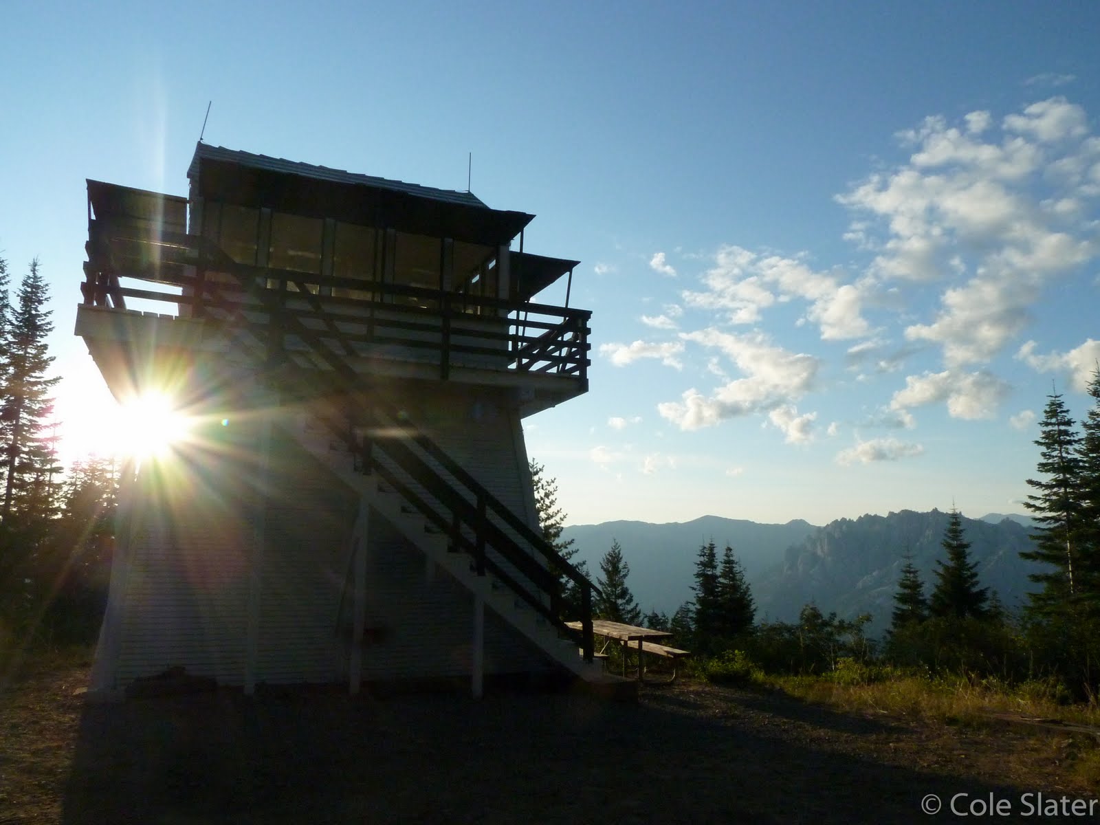
          We drove back to the historic Girard Ridge Fire Lookout to enjoy the last night of our vacation. We were treated to another awe inspiring sunset and stayed up late polishing off what booze or sweets we may have had left.

Girard Lookout Sunset


Sunset at Girard Ridge Lookout

Girard Ridge Fire Lookout - Day 7 - Trip Report - 9/16/11

          On the final morning at Little Mt. Hoffman Lookout we awoke and watched sunrise from bed. We took our time packing up, enjoying the ambiance among the cinder cones, mountain tops and lava flows.

Moonset over Little Mt. Hoffman Lookout


Little Glass Mountain, Pumice Stone Mtn. and Mt. Shasta

          Just before midday we departed from Little Mt. Hoffman passing by Medicine Lake before heading southwest on paved FR49. We passed by an interesting horse and wagon that we'd seen a few times throughout our stay there.

Wagon Time

          We drove several miles before stopping briefly to check out the Jot Dean Ice Cave. The mouth of the cave is just a short walk from roadside.

Mouth of Jot Dean Ice Cave

          We scrambled down into the opening just far enough to see a healthy chunk of ice on the ground of the cave.

Ice Chunk in the Jot Dean Cave

          It made me wonder if the natives ever utilized these caves for storing meats or other perishable items or if not just to cool off on a hot summers day.
          Just across the road from our parked car was a truck and trailer with some folks doing some shooting. The gunfire increased in rapid succession and the abrasive echo from each shot penetrated our ears and moved throughout the rest of our bodies like venom. With any chance of peace and quiet dissolved, we continued our drive along FR49.
          Sarah kept her eyes peeled for a natural arch she had seen when we had driven in on this same road a few days earlier. Her keen eyes located the arch and we stopped for another geological exploration.

Natural Bridge along FR49


Good Times!

          There are countless arches like this throughout the Medicine Lake Highlands and they were formed by partially collapsed lava tubes.
          We continued on through varied terrain, stopping at one point to admire a field of blooming desert chaparral.

Roadside View

          We made our way to Hwy 89 and headed west to the small fishing town of McCloud where we refilled our near empty gas tank. From there we drove to the city of Mt. Shasta where we stopped at Rays Grocery to get more food for the next couple of days. Planning such trips requires stopping every few days to replenish ice and Mt. Shasta is a convenient stopover.
          We ended up stopping in town at the Wayside Grill for a long relaxed lunch. It felt great to just sit back and be waited on while we kicked back a couple of pints.
          After a great meal it was time for another stopover, this time to take care of hygiene. Just out of town is the pleasant Lake Siskiyou where after paying a dollar day use entrance fee we had access to the showers. A couple bucks worth of quarters gets you a few minutes of steaming hot water. What a treat it was to walk out of there feeling clean and fresh, yet still in the woods!
          If the weather was warmer we would have gone for a swim but instead we hit the road en route to the Girard Ridge Fire Lookout located in the hills above Castella.
          From I5 near near Castella it is a several mile drive up a steep dirt logging road to reach the lookout. The amount of clear cutting you have to drive through is utterly disgusting and almost makes the place not worth visiting. All of the surrounding land, along with 3% of California, is owned by Sierra Pacific Industries a government subsidized evildoer who must be held accountable for their irreversible annihilation of our forests. But that is a separate post in itself.

Clear Cut Logging

          We arrived at the lookout and were once again at peace as most of the clear cut patches are not visible from there. We unloaded our gear up the steep stairway to the elevated cabin. First things first was enjoying a cold brew on the catwalk as we soaked in the views of Mt. Shasta and Castle Crags on the adjacent ridge.

Girard Ridge Lookout and Castle Crags


Mt. Shasta

          We enjoyed a quiet evening and just before sunset we saw a group of several large birds flying south that looked to be eagles? Without the binoculars handy we were unable to tell for sure. The sun sank behind the ridge and a few clouds lingered long enough to catch a hint of color.

Sunset with Last Light on the Crags


Castle Crags


Dusk at Girard Ridge Fire Lookout


Silhouette Sunset

          And yet another night of watching for fires! I did get up in the night to take a long exposure where I used my headlamp to paint the cabin with light. I was a bit careless with my headlamp and a few light trails are the evidence.

Girard Lookout at Night

Little Mt. Hoffman Fire Lookout - Lava Beds NM- Trip Report - Day 6 - 9/15/11

          Thursday morning dawned cold and crisp with clear skies. Photographically uninspired, I watched sunrise from the comfort of bed.
          I eventually got out of bed and went outside to stretch my muscles. Little Mt. Hoffman happens to be home to Talus Collomia a very rare wildflower found in only five locations throughout California. Its preferred habitat consists of volcanic talus or pumice stone. Not too far in the past, increased visitor traffic and off road travel had caused a significant decline in their population but thanks to efforts by Native Plant Societies a fence has been erected to help preserve habitat. We were lucky enough to be visiting while they were in bloom.

Talus Collomia (Collomia larsenii)


Talus Collomia Up Close

          These flowers are tiny and would probably go unnoticed unless you were aware and looking for them. Thankfully there was an interpretive sign to clue me in.

Interpretive Sign

          After breakfast we set off for Lava Beds National Monument located about 16 miles north along a graded dirt road. The condition of the road was fairly good except for the occasional pothole that caught us off guard. We only crossed paths with one other vehicle which goes to show that you should make sure you have a properly inflated spare tire and know how to put it on, because if anything were to happen you might be on your own for a while.
          We arrived at the south entrance to Lava Beds National Monument and I was surprised when there was not a fee booth. This park differs from most in that the fee station is located in the center of the park at the visitor center. Although most of the parks main attractions are located along the cave loop near the visitor center we decided to check out a couple of features located at the south entrance before making our way to pay our fee.
          Sarah waited in the car while I jogged down a short trail to check out Hidden Valley. As I was jogging I realized how different and unique the terrain was in comparison to where I normally hike in the Bay area and Sierra Nevada. I was filled with an unusual excitement and could feel the intense earth energy emanating from the region. I continued along the path until I reached a decent overlook of Hidden Valley.

Hidden Valley

          The sign at the beginning of the trailhead said .2 miles to the Hidden Valley overlook. Now I’m sure I had traveled more than .2 miles and yet the trail continued beyond the overlook I had stopped at. Perhaps there is a better overlook further down trail? With Sarah waiting for me back at the car I decided to turn around so that we could explore the next feature together.
          Directly across the road from the Hidden Valley trailhead is the starting point for The Big Nasty loop and Mammoth Crater. Sarah and I walked along the short paved path to the brink of the Crater where steel guard rails line the overlook. Although not as aesthetically stimulating as some of the other features, we were both quite impressed with the depth and girth of the crater.


At the Brink of Mammoth Crater

          We drove toward the visitor center and stopped at the Bunchgrass Overlook to contemplate our next adventure.

Bunch Grass Overlook


Bunch Grass Overlook

          Sarah’s energy levels were low, where as I could hardly contain my excitement. We had previously talked about hiking the steep .7 miles to the Fire Lookout on the top of Schonchin Butte but I compromised by choosing a short and level hike to Big Painted Cave.
          Before our hike we spent a good amount of time at the visitor center reading up on the interesting Modoc and geological history. Many people were renting helmets and flashlights for exploring the nearby caves, but with Sarah’s claustrophobia and us wanting to avoid crowds in general, we steered clear of any subterranean adventuring.
          We drove the short distance to the trailhead for Big Painted Cave and set off along the sandy trail. The trail zigzags across an old jumbled lava flow with access to a couple of smaller cave openings.

Sarah at the Mouth of a Lava Tube Cave


Lave Flow Jumbles

          About a mile in, just before we reached Big Painted Cave, Sarah decided that she would walk back to the car while I continued onward hoping to take some photographs. I knew Sarah was spent, so I did my best not to lollygag, but when I have a camera in my hand and I’m by my lonesome I tend to quickly lose track of time.
          I arrived at Big Painted Cave where I traversed the Southeastern edge of the lava crater which had a distant vantage of the cave opening and Schonchin Butte.

Big Painted Cave and Schonchin Butte


Big Painted Cave Opening

          I managed to find some blooming paintbrush which added a punch of color to the composition.

Big Painted Cave & Brushes


Paintbrush and Painted Cave

          I looped around to the actual opening of Painted Cave where an interpretive sign describes how the cave got its name.

Interpretive Sign

          Without a hiking partner I really did not feel inclined to enter the cave so I enjoyed the views from the exterior.

Another Cave Opposite Big Painted Cave

          It would be fun to come back with a flashlight and actually check out the pictographs. I toyed with the idea of traveling the extra half mile to see the Symbol Bridge cave, but out of respect for my wife I paced back toward the car.
          I found a small natural arch that went unnoticed on the hike in.

Natural Arch

          A short distance before returning to the car I noticed Sarah stopped on the side of the trail. She had seen a long snake and was waiting for me so that she could point it out. Unfortunately the snake had slithered away by the time I arrived and I missed a wildlife opportunity. She also mentioned seeing a giant wasp like bug that she had never seen before. After some research I’m guessing it was a Tarantula Hawk.
We made it back to the car and although I was itching to do some more exploring, it was evident that Sarah preferred to call it a day. I couldn’t complain, considering if she always went along with what I wanted to do we wouldn’t end up with much leisure time; And with as fast paced as our society is, leisure is something that is much needed. After all, we are on vacation.
          As we drove back toward Medicine Lake we pulled over at the Doorknob Snowshoe Park and took advantage of their picnic tables by having a relaxing lunch in the shade. The whole area seems to be a winter hot spot amongst snowmobile enthusiasts.
          On our way back to the lookout we stopped briefly at the day use lot for Medicine Lake. There we walked out onto the small beach area that looks out over the lake. Dozens of small frogs crawled along the sand and we were careful not to step on any as we made our way to the shore. We felt the water which wasn't too cold and if the weather would cooperate it would be nice for swimming.

Medicine Lake

          We then drove past the four campgrounds along the north side of Medicine Lake on our way back to Little Mt. Hoffman Lookout. After driving past Little Medicine Lake (more of a lily pad covered pond) we noticed a water spigot. This is helpful to know because there is no running water at the lookout and this is the closest available water.
          We arrived back at the lookout and went into relax mode. Threatening storm clouds seemed to be a accumulating and we were treated to a unique double rainbow over the lookout without the wet weather. I was unable to capture an image showing the two half circle rainbows encompassing the lookout tower but I did manage to snap off a few frames that portray the experience.

Rainbow over Little Mt. Hoffman Lookout


Rainbows End

          It was turning out to be an unforgettable trip.

Good Times!

          We spent the rest of the evening living the dream and enjoyed yet another vibrant sunset.

Fiery Clouds over Little Mt. Hoffman Lookout


Sunset


Sunset


Final Sunset over Little Mt. Hoffman Lookout

          There is undoubtedly good medicine at the Medicine Lake Highlands!