The sun was shining when I left work in Berkeley and headed for the hills of Marin to unwind and do some adventuring. Driving past Fairfax and the Alpine Club I parked at the base of Azalea Hill and the Pine Mountain Fire Road where there were only a couple other cars in the dirt lot. On weekends it can be quite a zoo unless you arrive really early.
The smell of blooming Ceonothus enveloped me as I started out on the Pine Mtn. Fire Road. A Red Tailed Hawk circled above while I made way along the first undulating fire road segment. The first few minutes of fairly level terrain are a great warm up before the climbing begins in earnest. As the trail climbs toward the Cypress Forest on top of San Geronimo Ridge the terrain is extremely rough and rocky consisting largely of serpentine outcroppings. It makes for one heck of a climb on a mountain bike I can tell you that.
Near the top of the first climb, about a mile from the parking lot, is the turnoff for Oat Hill Fire Road which follows a ridgeline heading south to its terminus at Oat Hill overlook. I took the Oat Hill turnoff and descended along the ridgeline and stopped briefly at the top of the Carson Falls Trail to admire the views around me. I had left work in the bustling city of Berkeley just an hour prior and now found myself a world away, immersed in a habitat much more to my liking.
Within the past few years a new trail has been built to reach Carson Falls as the old one has been retired. Although the old trail descended through open grassland offering views down the Little Carson Valley; It was far too steep for the meadow grasses to withstand the erosion. The newly built trail has many switchbacks and is built on sturdier soil beneath a forest canopy and with proper maintenance should stand the test of time.
While descending I kept my eyes out for creeping poison oak vines that were occasionally hanging out over the edge of the trail. Within a few minutes I was at the bottom of the valley where I crossed paths with the last hikers as they were leaving the falls. I would now have the place to myself for the rest of the evening.
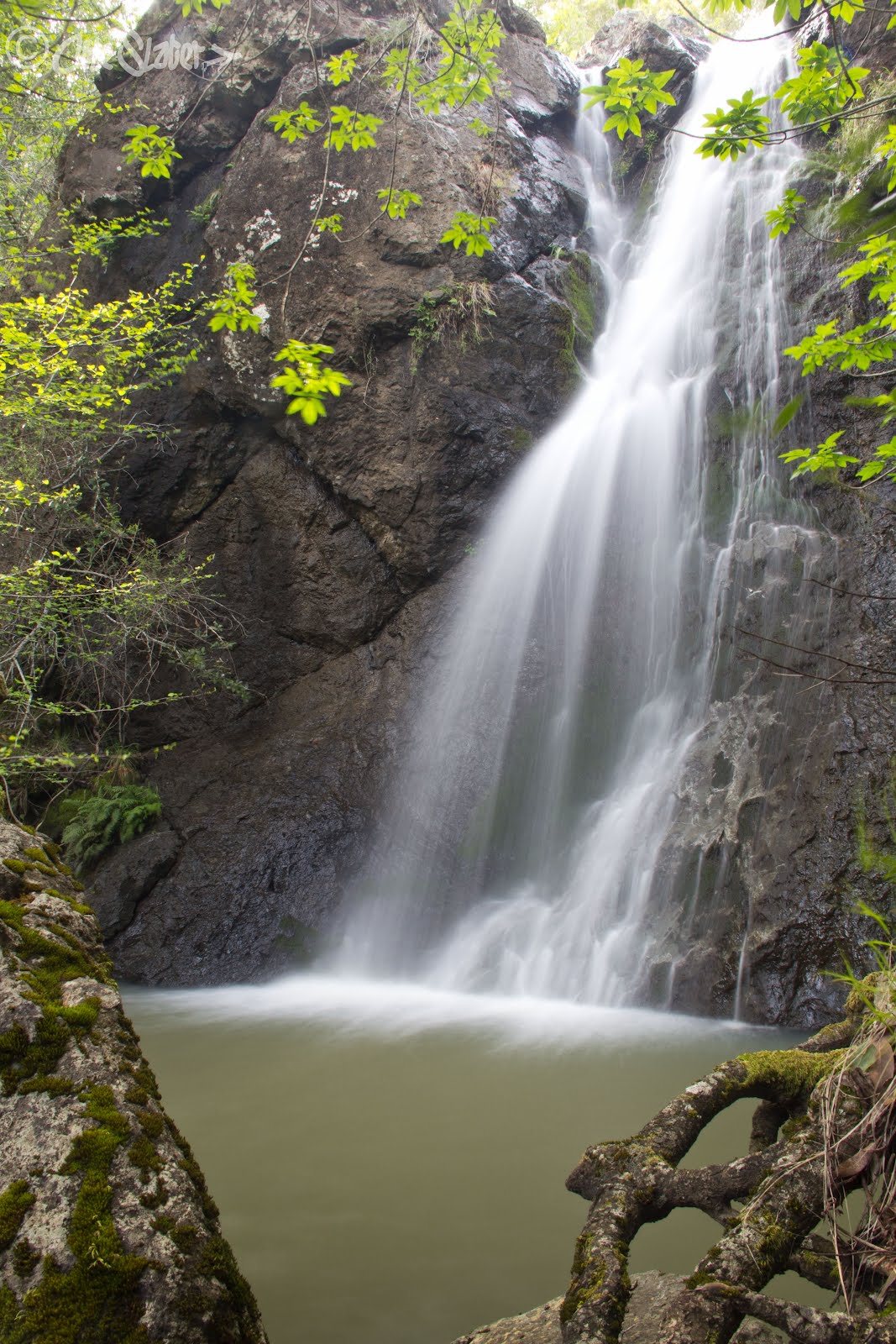
Carson Falls is really a series of waterfalls with magnificent pools along the top tiers and one long final plunge at the end. I started by crossing the creek above the falls via a footbridge and then descending along the far side of the creek toward the very bottom pool which resides in the deep shade.
The riparian habitat at the base of the falls is thick and tough to navigate but I managed to find a couple of vantage points without having to crawl through any poison oak.

While making my way back up towards the upper tiers I stumbled across a few camouflaged Fritillaria.

Beside the top tiers I relaxed and waited for the sun to dip behind the ridge so I could have better lighting on the falls. I was extra careful not to disturb the precious creek where Foothill Yellow-Legged Frogs lay their eggs during the spring.
As with most of my visits to Carson Falls and after careful observation, I was rewarded with a view of one of the rare frogs clinging to a rock beside the creek.

A State species of special concern the Foothill Yellow-Legged Frogs have disappeared from nearly half of their historic range throughout California and Oregon. Carson Falls happens to be one of the two remaining populations that remain in our area.
Although never fully safe throughout the year, March through June is the most vulnerable time for the eggs and it is important to keep away from the stream bed during these times so as to protect the eggs and future generations of frogs. Besides human and pet disturbances and damaged eggs the newly hatched tadpoles also face natural predation by other animals such as newts which I saw plenty of. Thankfully the MMWD has started a docent program where on busy weekends docents stand by to engage with and inform the public about the frogs and the importance of keeping pets on a leash. Barriers have also been erected to help prevent people from getting close to the water. These barriers aren’t the prettiest thing to look at and often times interfere with the view of the falls, but this is the growing issue we face as larger populations are drawn towards delicate ecosystems.
The sun eventually crept behind a ridge and I began taking some photos. I certainly got my workout as I made my way up and down the tiers looking for different compositions.


After making some images and relaxing I packed up my gear and began my hike out of Little Carson Valley. I was quite ecstatic to have had the place to myself for the entire evening. At the top of the ridge on Oat Hill Road I took a break to admire the shifting clouds and colors above Tomales Bay to the west.

I contemplated waiting for sunset but didn’t want to push dinner so far out and so started back towards the car. As I approached the final stretches of Fire Road an Osprey soared overhead as if to give me my farewell from my evening on the trails. I paused one last time to take in the fading clouds.


