This trip was dedicated to Sarahs’ Mother Mary Jan Bruce January 12 1950 – July 2 2001. In Loving Memory SAT:
 Our original trip plan had been to go to Lake Tahoe with another couple who owned a motorboat, however, last minute changes forced an improvisation and Sarah and I ended up taking a canoe by ourselves.
We hit the road at 4:00 AM and the trip began. Driving up Hwy 50 we stopped briefly along the way at Bridalveil Falls.

We pulled in to D.L. Bliss State Park and unpacked the canoe and gear at Lester Beach. I then drove the car up to the parking lot at Balancing Rock about a mile away and walked back to Sarah and a fully loaded canoe. At this point the water was choppy, however, being only 7:30 AM there were no motorboats on the lake yet. We paddled south along the pristine rocky shoreline.


With the threat of wind we paddled hard for a while to cover ground. Soon we passed several large osprey nests perched upon dead standing trees.

We continued south around a point to a small beach with no trail access.

We beached the canoe and hung out for a while. A large osprey nest towered above the beach from the point to the west. While sitting on the beach enjoying the views several osprey flew overhead—we named the beach “Osprey Beach”.
We pushed off and kept heading south toward Emerald Point.

Along the way we stopped to check out a creek cascading in to the lake.

By this time a few motorboats had made there way out on the lake; their wakes tossing us about. We passed a beach located at the start of Emerald Point where the Rubicon Trail snakes beside it and then towards Emerald Bay and Vikingsholm.

We paddled by another beach just beyond that which was fairly rocky but more secluded.

Then a magical experience occurred; Perched high in a leafless tree above us was a beautiful bald eagle.

Almost surreal, it watched out over the big blue while we positioned ourselves for a better view.

Out of nowhere a lone duck flying swiftly overhead curiously darted downward and landed next to the canoe.

It proceeded to swim right up to my hand and damn near let me pet it.


It visited with Sarah for a moment.

And then as quickly as it came, it up and flew away. All the while the eagle stood perched.
For the next half hour Sarah struggled slightly with small wakes keeping us with a great view of the eagle.

Unsure we were making the right decision, we paddled on.
At the mouth of Emerald Bay is where the water is the most rough due to wind patterns and the many motorboats entering and leaving the bay. We were careful to position ourselves correctly as to not capsize while we were bombarded with wakes from all directions. We entered the bay and immediately paddled to the northwest toward a secluded beach near the tip of Emerald Point.

From there we enjoyed a superb view of Emerald bay, Fannette Island, Eagle Falls, and the peak of Mt. Tallac towering over it all.

We unloaded most the gear from the canoe and set up day camp on the beach. Another Bald Eagle Flew from Eagle Point across the bay and above the rubicon trail. We knew this trip was something special already.
Although still morning, the sun was already hot so we lathered up with sunblock and laid out for while.

Being that it was 4th of July weekend the bay was extremely busy with boats and we compared it to watching a parade as the boats entered the bay one by one most of them to do a loop around Fannette Island and then head back out to the lake. Every so often the notorious tugboats would pass by and we would hear segments of the scripted tour speeches.


The lake temperature was not too cold so I went swimming.

We relaxed until it was time to check in to camp. Again, we loaded up the canoe and then paddled to the Boat Camp.

The Boat Camp is a fantastic campground with 20 sites, running water and pit toilets. There are mooring buoys for larger boats and smaller watercraft can pull right up on the beach. The Rubicon Trail passes right through the campground providing a mellow walking path in either direction. We stayed at site #10

which was located a little ways up the hill in the shade.

Wild flowers were just getting started and rising out of the pine needles was the strange yet magnificent Snow Plant.

We hung around camp for a while enjoying the shade. We then took a short walk along the Rubicon Trail heading in the direction of Vikingsholm. The trail crosses several wooden bridges and small steambeds.

Lupine surrounded the trail, however, they were another week or two away from blooming. By sunset, the hum of motorboats had faded and we started to really experience what the Boat Camp is all about. We built an early fire back at camp.

After dinner we retired to the tent as we were very tired from having woken up so early.
SUN: We awoke early and thought we would try to take advantage of the calm morning water by rowing out to the lake. After putting the canoe in and beginning to paddle we realized it was everything but calm. The wind had picked up and small waves were rolling in from outside the bay. We fought the current paddling toward the mouth and into the lake. By this time the swells were around 3 feet big and our canoe was bouncing over each one. With the fear of capsizing we swiftly maneuvered the boat in the opposite direction and paddled to safety over to the beach on Emerald point. This experience made us realize how hard it would be to paddle the fully loaded canoe back to Lester Beach if it were that windy. We crossed our fingers and hoped for good weather the next day.
Again we laid out on the beach and soaked up the sun as well as the views.


We practiced Qi Gong a while, then sat and watched the parade of boats begin.
After paddling back to camp and eating lunch we took a nap. Although it felt like we could sleep forever we pried ourselves out of the tent and took another stroll on the Rubicon Trail. We headed in the same direction as before but this time we went a little further and branched off trail to Parson Rock.

From here you have great views of Fannette Island.

Although we didn’t use it, there is a nice rock to dive off of into deep water. We rested upon the granite observing the lively lake on this 4th of July. Anchored between Fannete island and the shoreline in front of Vikingsholm was a group of boats gathered together to form a party, with music blaring and people dancing.
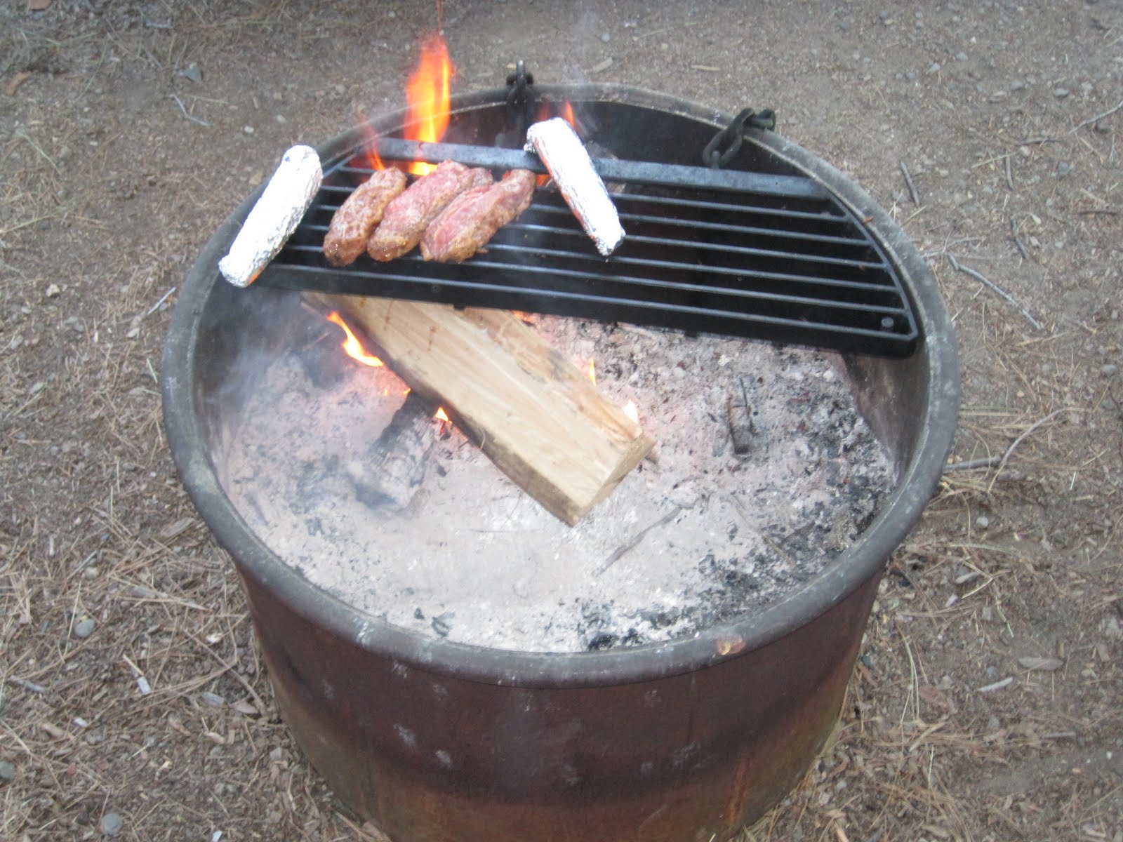
We walked back to camp and prepared a fire to cook an early dinner on. As we waited for the fire to get ready most of the motorboats had cleared out of the bay. What a stark contrast we noticed between midday and dusk in regards to the general noise level. We pulled out our marinating tri tip and corn on the cob and set them on the grill.

After a delicious dinner we packed our backpacks with all the supplies we would need for the fun night we had ahead of us. Just after sunset we put the canoe in and set off for Fannette Island. At this point there was but two motorboats in the bay and the water was still as glass. We pulled up to the southwest shore of the island where the party boats were earlier in the day and tied the canoe up. We set off on foot toward the peak of the island where the remains of an old tea house sits. Along the winding rocky trail to the summit we noticed many wildflowers.
 Leichtlin's Mariposa Lily
 Pride-of-the-Mountain (Penstemon newberryii)
At this point we had the whole island to ourselves, practically the whole bay. We entered the stone tea house and were struck by the view of Eagle Falls and Vikingsholm out one window


and the mouth of Emerald bay and its entirety out another.

We spent several minutes taking photos and thinking of what it would have been like back in the old days when they used to serve high tea there. We felt like we could spent a lot more time here, however, it was getting darker and we wanted to paddle out the mouth of the bay to find a spot to see the fireworks before dark. We half jogged back down the trail to the canoe.

We pushed off and cut through the water with ease as it was the calmest we would see for the trip.

We planned on leaving the canoe on the inlet of the bay to avoid any possible return boat traffic in the middle of the night as we paddled back. We beached our canoe on some rocks at the south side of the mouth of Emerald Bay and set off on foot along the shoreline.

We walked quite aways along the treacherous and rocky shoreline in hopes of getting the best view of the fireworks. We soon came upon a large rock with a flat surface large enough for Sarah and I to set up shop for the night.


With what felt like the whole lake to ourselves and a view of the majority of shoreline around Tahoe we were more than content.

We soon noticed a large osprey nest just behind us and up the hill. Several osprey flew overhead circling their nest. At one point one landed next to its nest.

It later climbed in the nest and we could see its head poking up from time to time.
We pulled out our mini cooler with ice and fresh limes and poured up some more Cuba Libres; after all it’s the 4th of July. As the sky darkened we were blessed with the pleasant hues of color cast upon the skies to the east. A little after dark around 9:30PM two firework shows started in the north shore.

We couldn’t help but let out a loud holler of excitement. A couple minutes later another firework show started on the northeast shore. We were now staring with awe and excitement at three simultaneous firework displays in the distance. Just as we finished watching the finales on the north and east side, the famous South Shore fireworks show began.

We were just close enough to feel like we were at the show, but with total seclusion and the place to ourselves. The weather could not have been better with next to no wind and a comfortable temperature. We cheered as each mortar exploded!

On the bigger blasts the lake would light up in a natural mystic.

Several minutes into the show another display of fireworks erupted along the shoreline by the casinos.

The show over there was a dual display of mortars exploding side by side.

We were now enjoying two of some of the greater fireworks displays in the nation.

To us this experience was exhilarating and somewhat unreal. We felt truly lucky to have been experiencing such extraordinary views with so much solitude. Both of the south shore finales were spectacular!


After watching the boats on the lake flee the south lake area we gathered our belongings under the light of our headlamps and a battery lantern we had brought along. At this point, after several drinks each, we realized walking back along the rocky shore was going to be a lot more difficult. We took it slow and stumbled often, but we managed fine. By the time we got to our canoe all of the boats staying at the boat in sites were back at their mooring buoys and once again we had the entire bay to ourselves. We paddled in the dark across the bay. Although close to midnight we had plenty of energy and contemplated paddling to Fannette Island and hanging out in the tea house. We came to our senses and decided to head back to camp instead. It was fun paddling through the calm waters of Emerald Bay in the dark of the night. Once at camp we started a fire and indulged in s’mores. Well after midnight we put out the fire and passed out.
MON: Although we were tired from a long night we wanted to take advantage of the calm early morning waters free from swells and wakes from the motorboats. We dragged ourselves out of the tent and packed up camp. We loaded the canoe and pushed off just before 8:00AM. We said goodbye to Eagle Falls and our home for the past two days as we paddled out the mouth of Emerald Bay.** We paddled south along the shoreline of Emerald Point when again we were blessed with the sighting of a Bald Eagle perched on his massive tree.** We paddled in place for several minutes enjoying the Eagles majestic presence before moving on. **We continued north crossing paths with a solo kayaker and a single motor boat dragging a water skier. We beached the canoe on what we called “Osprey Beach” and quickly heated up in the morning sun. We took a quick dip in the cool water to wake us up and refresh us. Without any shade on the beach we soon felt the need to push off. We paddled north along the steep rocky slopes plunging into the depths of the dark turquoise water. ** We pulled up onto Lester Beach and Sarah unloaded the gear from the canoe while I hiked the mile up hill to get our car which was parked at the overflow lot at “Balancing Rock”.
When I returned with the car, Sarah had all the gear stacked in a pile ready to be loaded. We both agreed that Lester Beach is one of the better beaches in the Tahoe area. The water color was unbelievable and lots of soft sand. A gander of geese then swam close to the shore to visit.**
We finished loading the car and drove off heading for Big Meadow trailhead near Luther Pass. Because it was 4th of July weekend the traffic was horrendous. It took over two hours to drive the 20 miles from D.L. Bliss State Park through South Lake Tahoe to Big Meadow Trailhead.
When we arrived at the trailhead we parked in the shade and made lunch alongside the car. With our energy levels at a low for the trip we decided to change our hike into more of a walk. We walked up the Big Meadow Trail which follows the creek as it switchbacks its way to the junction with the trail to Scotts Lake.** From there it is a short distance to the Big Meadow. Last time I was here it was late in the season and everything was dry and golden. This time everything was green** and the wild flowers were starting to come out.** This particular flower was my favorite of the trip.**We walked through the meadow and then briefly off trail to the outskirts. The mosquitoes started swarming and we fought back with DEET. It only slightly deterred them. We enjoyed great views of the length of the meadow.**The corn lilies were abundant but not yet in bloom.**We sat on a fallen tree for a moment and soaked up the gorgeous alpine scenery. We then slowly walked back the way we came toward the car. I went off trail briefly near HWY 89 to check out a cascading waterfall in the creek.**We got back to the car and the drove toward Hope Valley and the junction of Hwy 89 and Hwy 88 where there is a day use parking lot. We took a stroll on a path that leads to the west fork of the Carson River.** Hope Valley and the surrounding areas is one of Sarah and I’s favorite places to be. The old Hwy 89 is now used as a hiking / biking path and leads through a gorgeous section of the meadow and then slightly inclines up into groves of Aspen which show their brilliant color in the fall.
We left the day use area and decided to avoid traffic by returning home via Hwy 88. This was a scenic drive as it passes Red Lake then climbs Carson Pass and past Caples and Silver Lake. The views and surrounding terrain caused us to drive extra slow to take it all in.
The forested landscape turned to golden rolling hills as we left the Sierras and entered the foothills. The sun was setting as we crossed the San Rafael / Richmond Bridge and within minutes we were in the comfort of our home.
© copyright 2010


 The road is hard to follow as countless other logging roads and spur trails intersect from all directions.


 The water temperature could not have been nicer at about 70 degrees. The views of snow capped Crystal Range in the distance made a nice backdrop for beautiful Jenkinson Lake.

 After the sun took its toll on us we rode the bikes back along the Mormon Emigrant Trail to Sly Park Rd. and then back to the cabin. Although there is a nice trail that parallels Sly Park Rd. we were beat from the sun and took the easy route on the pavement. The trail that we opted not to take starts 1/3 of a mile past the junction of Sly Park Rd. and Mormon Emigrant Trail and ends at the fire station right across the street from Sly Guard Cabin


 This is the undeveloped shoreline that you can access without having to pay a fee at the Jenkinson Lake Recreation Area. Several people had their beach towels and picnics set up along the shoreline. We continued onward to try to find a nice secluded spot of our own.