FRI:
We made great time on our drive up north despite it being Friday afternoon. Interstate 5 seemed to speed things up a bit. Shortly after 9 PM we arrived at our destination Cave Springs in the historic town of Dunsmuir, Ca.
Cave Springs is a funky little spot just off of I5 situated right alongside the Sacramento River. It is a Motel, but they also offer rustic cabins and other vacation rentals. We had the pleasure of staying in one of the rustic cabins. I had stayed here once before as a child for 4th of July and remember having a great time. Let me reiterate that Cave Springs’ Cabins are “Rustic” with all the state of the art amenities of 1923. If you go there expecting anything more you could be disappointed. With that being said, it is a perfect jumping off point for many adventures in the greater Mt. Shasta area. Cave Springs is not the quietest of places. You’ve got traffic noise from I5 which is mostly droned out by the sound of the Sacramento River. You also have a set of live train tracks that parallel the river on the opposite side with several trains coming through each day and night. Despite Sarah’s extreme sensitivity to noise, we were able to fully relax and enjoy ourselves.
After a long day at work and the lengthy drive we went to sleep fairly early. Just as we lay down to sleep we heard loud music coming from outside. I opened the door to hear what sounded like band practice. At the time, I couldn’t pin point where the noise was coming from but figured it was one of the nearby residences. Soon all I could hear was the sound of a drum set. Again I opened the door, this time to hear a drum solo. This was no ordinary drum solo… You know when you’re at a concert and they give the drummer about a minute to show off their stuff. Well this was about 15 minutes of that. Non stop, fast paced, incredible drumming. I was imagining a crazy looking guy jacked up on methamphetamine, pouring gallons of sweat out of his head while drumming like there was no tomorrow. It eventually ended and we got to sleep. As we would later find out “The Big Brother & the Holding Company” (Janis Joplin’s original band) was playing the next night at the baseball field just down the street. I’m guessing that was sound check?
Sunday, September 19, 2010
Mt. Shasta Area Trip - 9/11/10 Day 2 - Castle Dome Hike , Castle Crags State Park
SAT:
We woke up and had a slow morning relaxing on the back deck overlooking the Sacramento River. We noticed that our cabin was right next to an overlook with benches looking out over the river with views of Mt. Shasta in the distance.
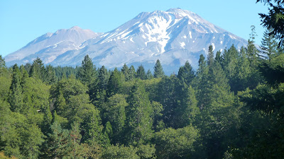
View of Mt. Shasta from the lookout
At about noon we decided we would go for a hike.
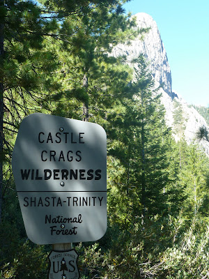
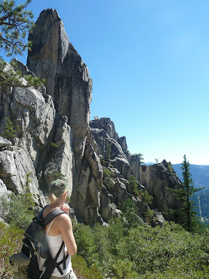
We drove about 10 minutes south to Castle Crags State Park. We paid our $8 day use fee (thanks Schwarzenegger!) and parked at the Vista Point parking lot. From there we started off on the Crag Trail toward Castle Dome. For the first several minutes the trail is completely shaded and flat. We soon came to the junction with Root Creek Trail where we stayed left and started climbing moderately. A little more climbing brought us to the junction with the PCT. Still under the shade of Fir, Pine and Cedar we continued uphill for about another ½ mile before passing a junction with Bobs Hat Trail. A little more uphill and a few switchbacks later the trail offers broken views of the crags.
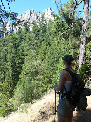
First broken view of the crags
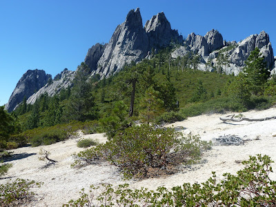
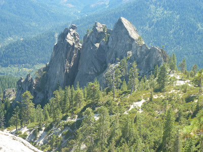
We then came to the junction with Indian Springs Trail which we would take on our way down. Onward brought us to the beginning of Castle Crags Wilderness.
Castle Crags Wilderness with Castle Dome in the backdrop

Castle Dome and Mt. Shasta
From here the trail emerged out of the forest and into the hot sun. Manzanita was now the main chaparral. The footing became very rocky and much steeper. Countless climbers’ trails spur off in different directions. At times it is tough to follow the main trail. We were thankful the majority of the hike up until this point was in the shade because it was hot out. This is where the hiking starts to get exciting as you enter the crags.
Entering the Crags
From here until trails end the heat would be relentless. We pushed on earning greater views of the crags.
Random crag with evidence of logging in the background
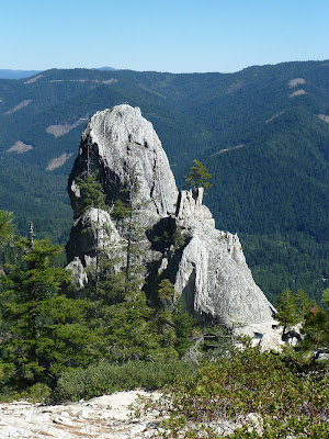
Castle Dome, today's destination, is in clear view.

Castle Dome getting closer

Resting in the Shade for a moment on the way up
A little ways further and shortly before the trail ended we opted to venture off trail and find a patch of shade to rest at.
View from our resting spot
From here we looked out across to Girard Ridge and located Girard Fire Lookout, where we would be spending Tuesday and Wednesday night.
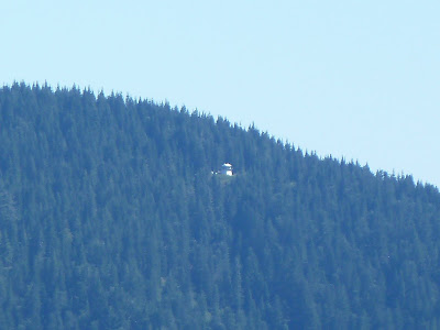
Girard Lookout From a Distance
We were very excited. Unfortunately with the good views come the bad as well; The landscape is scarred badly with patches of logging clear cuts as far as the eye can see. It is a sad sight!!!
Sarah decided to rest as I hiked the few hundred yards to trails end.
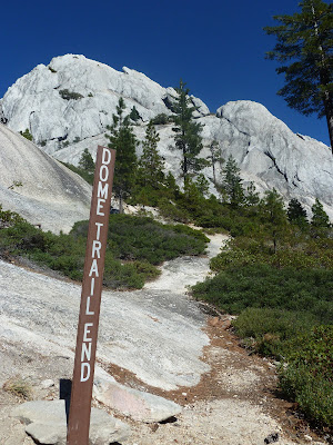
Trail end with Castle Dome looming above
From here I scrambled up Castle Dome a ways until it got too dangerous.

View from Castle Dome Cliffside
It’s too bad the trail doesn’t explore the heart of the Crags. Perhaps someday Sarah and I will do some cross country exploration. I rejoined Sarah in the shade and we took in the views. One Crag in particular slightly resembles a crown therefore I've named it "Corona Crag".
"Corona Crag"
With the sun getting lower in the sky we decided to head back.
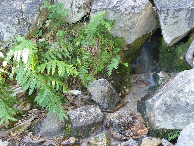
We took the Indian Springs spur trail which was a mostly flat 5 minute walk to the springs themselves.

Indian Springs Trail
Indian Springs flows year round and is the only water on this hike.
Indian Springs
Insects swarmed the area so we only spent a few moments wetting our faces before moving on.
From there it was back into the shade and downhill, mostly uneventful but enjoyable nonetheless. At the parking lot there is a short path to the “vista point” where there are free telescopes to view the Crags and Mt. Shasta.
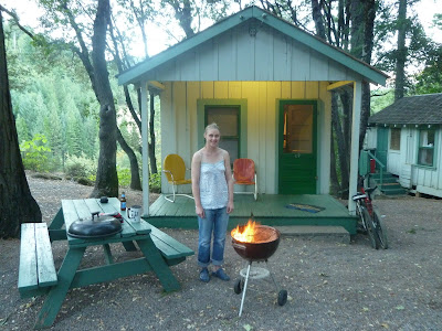
Back at the cabin we BBQ’d out front while enjoying the sounds of “Big Brother & the Holding Company” with a Janis Joplin cover.
Barbecuing in front of our cabin
We woke up and had a slow morning relaxing on the back deck overlooking the Sacramento River. We noticed that our cabin was right next to an overlook with benches looking out over the river with views of Mt. Shasta in the distance.

At about noon we decided we would go for a hike.
We drove about 10 minutes south to Castle Crags State Park. We paid our $8 day use fee (thanks Schwarzenegger!) and parked at the Vista Point parking lot. From there we started off on the Crag Trail toward Castle Dome. For the first several minutes the trail is completely shaded and flat. We soon came to the junction with Root Creek Trail where we stayed left and started climbing moderately. A little more climbing brought us to the junction with the PCT. Still under the shade of Fir, Pine and Cedar we continued uphill for about another ½ mile before passing a junction with Bobs Hat Trail. A little more uphill and a few switchbacks later the trail offers broken views of the crags.

We then came to the junction with Indian Springs Trail which we would take on our way down. Onward brought us to the beginning of Castle Crags Wilderness.


From here the trail emerged out of the forest and into the hot sun. Manzanita was now the main chaparral. The footing became very rocky and much steeper. Countless climbers’ trails spur off in different directions. At times it is tough to follow the main trail. We were thankful the majority of the hike up until this point was in the shade because it was hot out. This is where the hiking starts to get exciting as you enter the crags.

From here until trails end the heat would be relentless. We pushed on earning greater views of the crags.

Castle Dome, today's destination, is in clear view.


A little ways further and shortly before the trail ended we opted to venture off trail and find a patch of shade to rest at.

From here we looked out across to Girard Ridge and located Girard Fire Lookout, where we would be spending Tuesday and Wednesday night.

We were very excited. Unfortunately with the good views come the bad as well; The landscape is scarred badly with patches of logging clear cuts as far as the eye can see. It is a sad sight!!!
Sarah decided to rest as I hiked the few hundred yards to trails end.

From here I scrambled up Castle Dome a ways until it got too dangerous.

It’s too bad the trail doesn’t explore the heart of the Crags. Perhaps someday Sarah and I will do some cross country exploration. I rejoined Sarah in the shade and we took in the views. One Crag in particular slightly resembles a crown therefore I've named it "Corona Crag".

With the sun getting lower in the sky we decided to head back.
We took the Indian Springs spur trail which was a mostly flat 5 minute walk to the springs themselves.

Indian Springs flows year round and is the only water on this hike.

Insects swarmed the area so we only spent a few moments wetting our faces before moving on.
From there it was back into the shade and downhill, mostly uneventful but enjoyable nonetheless. At the parking lot there is a short path to the “vista point” where there are free telescopes to view the Crags and Mt. Shasta.
Back at the cabin we BBQ’d out front while enjoying the sounds of “Big Brother & the Holding Company” with a Janis Joplin cover.

Mt. Shasta Area Trip - 9/12/10 Day 3 - Mossbrae Falls Hike , Lake Siskiyou , Castle Lake
SUN:
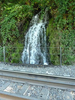
After breakfast we set off on the bikes to check out Mossbrae Falls. From Cave Springs we headed north on Dunsmuir Ave. for about a block before turning left on Scarlett Way (Shasta Retreat). We rode a short ways downhill and then over a bridge crossing the Sacramento River where we locked our bikes next to the train tracks. From there it was about a mile walk along the tracks to the spur trail leading to Mossbrae Falls. The train tracks parallel the Sacramento River offering great views along the way.
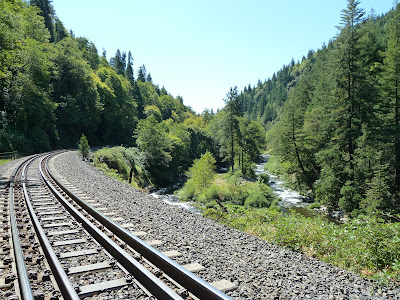
Rail Trail to Mossbrae Falls with Sacramento River on the right
Be aware that the tracks are live and trains do come by frequently, as we crossed paths with one on our way to the falls.
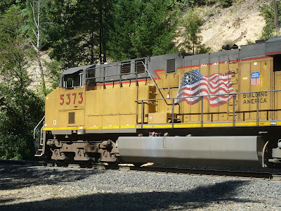
Patriotic Engine
Just before a steel bridge is the path leading to the falls. Mossbrae Falls is nothing short of amazing!
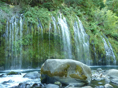
Mossbrae Falls
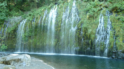
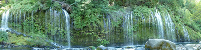
Panoramic --Click Image To Enlarge--
We enjoyed the beauty of the Falls for quite some time before moving on. It’s hard to leave such a magical place.
We headed back out to the tracks and crossed the steel bridge.
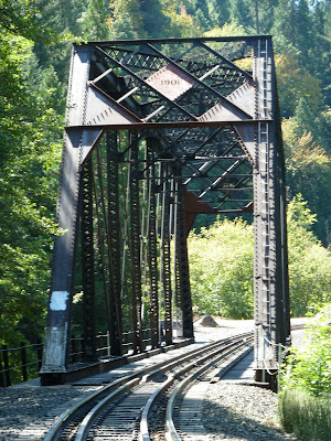
110 Year old Steel Bridge
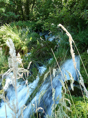
Just across the bridge were some blackberry brambles with some good picking. A short ways further down the tracks brought us to the first in a series of small waterfalls.
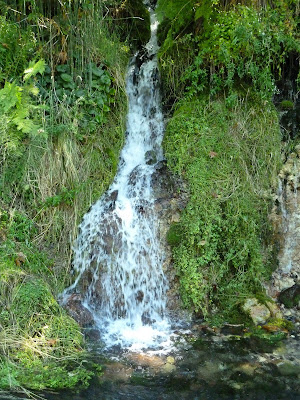
Small Waterfall
Wildflowers are more prevalent on this side of the bridge, perhaps because of the shade offered.

Crimson Columbine
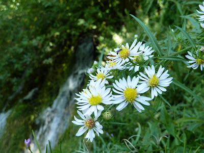
Aster or Daisies
Several hundred feet further down the track brought us to more waterfalls.
Spring

Another Spring
Because most people turn back after Mossbrae Falls we had this area all to ourselves. We continued a short ways further to Shasta Springs, the old location of a Resort where the train would stop to let passengers drink the fresh spring water. The resort is long gone but the springs remain. There are two good sized waterfalls emerging from the hillside, unfortunately they are terribly overgrown and it is hard to get a good view.
Shasta Springs
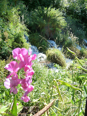
Sweet Pea & Shasta Springs
It was mid day and the sun was strong as we walked back along the tracks towards the trailhead.
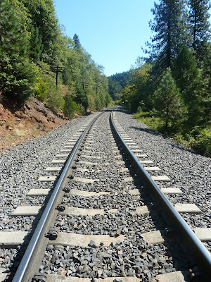
Hot Tracks
We made it back to our bikes in short order and rode back to our cabin at Cave Springs.
After lunch we drove north on I5 for several minutes before exiting in Mt. Shasta and heading to Lake Siskiyou. We parked in the lot just before the damn and walked down to the shoreline.
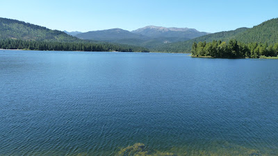
Lake Siskiyou
We decided to drive over to the marina by the campground and see about a boat rental. Unfortunately none were available so we moved on.
We drove a short ways to Castle Lake rd. and from there it was seven miles on a mountain road to Castle Lake. The road to Castle Lake offers great views of Mt. Shasta and Black Butte as well as great dispersed camping.
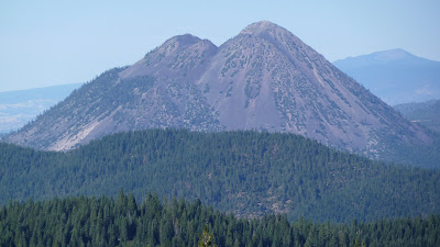
Black Butte
Castle Lake is beautifully set in a cirque surrounded by cliffs. There is a trail leading along the east shore of the lake which ascends to Little Castle Lake and Bradley Ridge with an optional spur trail to Heart Lake. We will do the full hike on another adventure, on this trip we walked a short ways down the trail and found a nice spot to sit by Castle Lake. Kayaking and fishing was popular and we even saw a couple of swimmers as well.
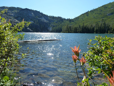
Castle Lake & Paintbrush
We then headed back to Dunsmuir for the rest of the evening.
After breakfast we set off on the bikes to check out Mossbrae Falls. From Cave Springs we headed north on Dunsmuir Ave. for about a block before turning left on Scarlett Way (Shasta Retreat). We rode a short ways downhill and then over a bridge crossing the Sacramento River where we locked our bikes next to the train tracks. From there it was about a mile walk along the tracks to the spur trail leading to Mossbrae Falls. The train tracks parallel the Sacramento River offering great views along the way.

Be aware that the tracks are live and trains do come by frequently, as we crossed paths with one on our way to the falls.

Just before a steel bridge is the path leading to the falls. Mossbrae Falls is nothing short of amazing!


We enjoyed the beauty of the Falls for quite some time before moving on. It’s hard to leave such a magical place.
We headed back out to the tracks and crossed the steel bridge.

Just across the bridge were some blackberry brambles with some good picking. A short ways further down the tracks brought us to the first in a series of small waterfalls.

Wildflowers are more prevalent on this side of the bridge, perhaps because of the shade offered.


Several hundred feet further down the track brought us to more waterfalls.


Because most people turn back after Mossbrae Falls we had this area all to ourselves. We continued a short ways further to Shasta Springs, the old location of a Resort where the train would stop to let passengers drink the fresh spring water. The resort is long gone but the springs remain. There are two good sized waterfalls emerging from the hillside, unfortunately they are terribly overgrown and it is hard to get a good view.


It was mid day and the sun was strong as we walked back along the tracks towards the trailhead.

We made it back to our bikes in short order and rode back to our cabin at Cave Springs.
After lunch we drove north on I5 for several minutes before exiting in Mt. Shasta and heading to Lake Siskiyou. We parked in the lot just before the damn and walked down to the shoreline.

We decided to drive over to the marina by the campground and see about a boat rental. Unfortunately none were available so we moved on.
We drove a short ways to Castle Lake rd. and from there it was seven miles on a mountain road to Castle Lake. The road to Castle Lake offers great views of Mt. Shasta and Black Butte as well as great dispersed camping.

Castle Lake is beautifully set in a cirque surrounded by cliffs. There is a trail leading along the east shore of the lake which ascends to Little Castle Lake and Bradley Ridge with an optional spur trail to Heart Lake. We will do the full hike on another adventure, on this trip we walked a short ways down the trail and found a nice spot to sit by Castle Lake. Kayaking and fishing was popular and we even saw a couple of swimmers as well.

We then headed back to Dunsmuir for the rest of the evening.
Mt. Shasta Area Trip - 9/13/10 Day 4 - Mccloud River Trail Hike & Bike , Mccloud Falls
MON:
Our original plan was to pack up and camp at Fowlers Campground near Mccloud. But we opted instead to stay at Cave Springs another night and do a day trip to the Mccloud area and hike the 3 Waterfalls Hike along the Mccloud River Trail.
We packed our lunch and set off driving north on I5. We then took HWY 89 (Volcanic Legacy Hwy) towards Mccloud and then the River Loop Rd. to the Lower Falls Day Use Parking lot. The River Loop Rd. seemed newly paved as the last time I was here in ‘99 the roads were dirt.
A few feet from the parking lot is a viewing platform looking over Lower Mccloud Falls.


I remember jumping off the cliff into the pool below last time I was here, however, the Forest Service has since removed the steel ladder that assisted one with climbing back out. We continued along the Mccloud River Trail which for the next ½ mile or so is paved.

The trail leads through Fowler's Campground and then turns to an actual dirt path and heads toward Middle Falls. It parallels the Mccloud River with many spur trails leading to the river bank.


The trail is mostly level save for a 300’ climb after Middle Falls. We soon came to Middle Falls which in my opinion is the most spectacular of the three. There is a perfect swimming pool at the base of the falls if you can brave the icy cold waters.


We then headed up several switchbacks which amount to the only elevation change on the hike. Once above the falls the trail follows the edge of a steep cliff offering views of the falls below. A short ways further brought us to the canyon that holds the Upper Falls.

The vantage point of the Upper Falls is not quite as good as the others. There are a couple of sketchy use trails leading down the very steep bank to the river below that might offer better views, but today we kept to the main trail. Because the Mccloud River Road Loop has spurs leading to all of the Falls it brings easy access to cars and non-hikers, therefore the trail segments between the Falls are the most secluded.
We observed the Upper Falls for a while before moving up river just a bit to stop for lunch. We found a nice location along the Mccloud to have a picnic.


The surrounding area was covered with volcanic rocks and signs of old lava flows. While eating lunch the chipmunks were relentless and bold with there attempt at a free meal. It actually became quite bothersome as they were obviously accustomed to humans and would not let up.

The Mccloud River Trail continues for another 13.4 miles to the Algoma Campground, however, we retraced our steps to the car stopping again at all of the points of interest.
Once at the car we drove up the Mccloud River Rd. to the Upper Falls Parking Lot near our lunch spot. Sarah rested in the car while I went on a mountain bike ride on the Mccloud River Trail. I rode up river along a beautiful singletrack trail. The beginning of the trail starts off bumpy and technical with one mean rock garden in particular. I soon came to Lakin Dam.

From here the trail gets less technical yet softer and it takes a little extra effort to keep the wheels turning. I crossed a couple of forest service roads and continued to a wooden viewing platform along the river.

I rode a little ways further down the singletrack before turning back. On my way back as I was riding along the river I heard some splashing noises. I got off my bike expecting to see some birds but instead saw several river otters playing around.

It didn’t take long for me to ride back to the parking lot where Sarah was waiting. From there we drove back to our cabin at Cave Springs and BBQ’d before going to sleep.
Mt. Shasta Area Trip - 9/14/10 Day 5 - Hedge Creek Falls , Lake Siskiyou , Girard Fire Lookout
TUE:
We woke up, ate breakfast and packed up the car. From there we drove north a short distance on Dunsmuir Ave. to the City Park where Hedge Creek Falls are located. We parked and walked the 5 minute path down to the Falls.

Hedge Creek Falls is an interesting waterfall in that you can walk behind it.

I’m sure the intensity of the falls would be best in spring when the water levels are much higher.
We walked back to the car and drove north to Lake Siskiyou in hopes of renting a pontoon boat. When we arrived at the marina the pontoons were not available so we opted for a “deluxe fisher”. This was a great option as the boat offered a sun canopy and comfortable seating. We brought our cooler and a picnic and set out on the lake.

The water was very still for the better part of our outing.


We explored the shoreline and enjoyed the views passing by a beautiful blue heron at one point.

The speed limit on the lake is 10 MPH so there are no big wakes which is nice. At one of the lake arms a new bridge was under construction.

Before we knew it our two hours were nearly up and we headed back to the marina.
We then drove south on I5 to the Soda Creek Exit. From there we took several miles of dirt roads up Girard Ridge to the historic Girard Fire Lookout. Unfortunately the roads leading up to the lookout are all on privately owned land used for logging. The name of the logging company is Sierra Pacific Industries and they are NOT friends of the forest. As we headed up the ridge to the lookout we passed many clear cut logging patches. It was seriously depressing.
As we pulled up to the lookout we knew we were in for a real treat as the views were spectacular.

The Fire Lookout itself is an elevated cabin with a catwalk lookout. There are two twin beds, a table, some storage cabinets and one hell of a view! We wasted no time unpacking our gear and getting into relax mode. We spent the rest of the day and evening simply gazing at the views of Castle Crags and Mt. Shasta.


Subscribe to:
Posts (Atom)