Monday, December 20, 2010

Day Hike - China Camp State Park - Shoreline Trail - 12-19-10

           After being cooped up in the house all weekend due to rainy weather we decided to motivate and grab our rain gear and get out for a short hike at China Camp State Park. To download a park brochure and map click here.
           We drove north on San Pedro Road and parked in a pullout just south of the China Camp Village entrance. From here we crossed the street and accessed the Shoreline Trail.

Shoreline Trail


         After about a half mile the rain picked up enough to require a rain jacket, however, we never did need our rain pants. Paralleling the road, the hard packed trail leads north offering views of the bay and Rat Rock Island.

Rat Rock Island


China Camp Village picnic area soon comes into view with its manicured green lawns.

China Camp Village Picnic Area


We saw a pair of Red Shouldered Hawks scanning the area for prey.

Red Shouldered Hawk


Red Shouldered Hawk


Throughout the entire hike we would hear the shrieks of Red Shouldered Hawks as they communicated with each other.
          Continuing straight, we soon passed a signed junction with a spur trail leading down to China Camp Village. The trail undulates slightly as it weaves through forested areas and open grassland. While rounding a bend in a forested area we were greeted by several deer feeding in the near distance.
           The Shoreline trail and China Camp in general is very popular with mountain bikers, however, on this rainy day we only crossed paths with two.

Easy Going


          We noticed a squirrel perched on top of a Bay tree, listening to the shrieking hawks in the canopy above.

Gray Squirrel


Views of the marshlands opened up as we rounded a corner.

China Camp Marshlands


          We then passed another signed junction with the Peacock Gap Trail which offers a loop option for this hike. Losing elevation slightly, the trail dips down closer toward the shore and a recent detour forces a descent to Bullhead Flat near the Ranger Station. Bullhead Flat is a pleasant place to put-in a canoe or have a BBQ.

Bullhead Flat


          We traveled along the pavement for a brief moment before regaining the lost elevation and getting back onto the original trail. We followed the path slightly downhill and then veered off trail and crossed San Pedro Rd. to get to Chicken Coop Hill.

Chicken Coop Hill and Marsh


View from the base of Chicken Coop Hill


          We climbed the short steep trail to the top of the Hill with hopes of a great view however; we were greatly disappointed as it was engulfed in tree cover. It was a fairly flat place to relax and there was a short spur trail leading downhill that offered decent views of the marsh flats.
          We relaxed a short moment before retracing our steps back to the car.


China Camp Marshland


Ravens Perch


         Just before we reached the car we saw some very interesting mushrooms that went previously unnoticed.

Interesting Amanita(?)Mushrooms

Saturday, December 4, 2010

Day Hike - Marin - Northside Trail Loop - 12/4/10

Mt. Tamalpais Loop Hike Trails Overview : International Trail, Northside Trail, Old Indian Fire Trail, Eldridge Grade, Old Railroad Grade, Miller Trail.

Hike Map - Click to Enlarge


Late morning we drove up toward the East Peak of Mt. Tamalpais and parked at one of my favorite “lesser known” trailheads. A little ways before you reach the East Peak parking lot on RidgeCrest Blvd. there is a section of road at a sharp turn with a pullout on both sides. This is the jumping off point for several trails including Lakeview, Miller, and International, all of which lead to significantly different environments. The reason I like this trailhead so much is because you have the option of going to either the north or south side of the mountain as well as to the East Peak Summit.

Wonderful Display of Light over S.F Coast


View Looking Southwest from the Pullout


We started our hike by heading north on the International trail; named so because it was built by a labor force made up of many different nationalities.
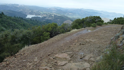
Trailhead


The trail starts off traversing the hillside a ways with short sections of slight uphill travel. Soon veering downhill we crossed a signed junction with the Colier Spring Trail which leads steeply downhill to Colier Spring itself and then straight down to Lake Lagunitas. We stayed straight on the International Trail. Continuing downhill the trail starts to get a little rocky before dead ending at a T junction with Upper Northside Trail. Going left leads to Rifle Camp and Potrero Meadow, however, we went right toward Colier Spring. Northside Trail is one of my favorite trails on the mountain mainly because of the solitude it provides. On any given day you are likely to have the trail to yourself save for a few deer and wildlife. Upper Northside is relatively flat and the trail soon opens up offering views of Lake Bon Tempe, Pilot Knob and Mt. Baldy below.

Upper Northside Trail


Pilot Knob & Mt. Baldy (Bald Hill)


A short ways further brought us to Colier Springs and the junction with Lower Northside and Colier Springs Trails. There are a couple of wooden benches set beside the creek and several lush ferns that make for a nice setting. A pair of wooden boardwalks assist with protecting the springs as the trail passes over them. Colier Springs is named after John Monro Colier a Scottish man who helped preserve the spring at Potrero Meadows, as well as build trails.

Boardwalk over Colier Spring


Benches at Colier Spring


Now on Northside Trail proper we remained under the forest canopy for the next couple of miles. We stepped over a salamander on the trail.

Salamander


Along the way we passed by a junction with the old Lagunitas Fire Trail which leads from the West Peak straight down to Lake Lagunitas. The trail is no longer maintained and is marked as “closed” on most maps. I believe it is mostly used now as an extremely technical downhill mountain bike trail also known as “Thousand S’s”. As the trail curves around a bend the Gardner Lookout on East Peak comes into view.

East Peak Gardner Lookout


Toward the end of Northside Trail the forest thins out and leads to Inspiration Point, a nice rock outcropping that is now mostly overgrown greatly taking away from the inspirational views.

From Inspiration Point we had the option of taking a short connector Fire Road to the Eldridge Grade, but we instead opted to venture up the steep and rugged East Peak Fire Trail. The East Peak Fire Trail is another little known about rarely if ever maintained erosion prone trail built in the earlier days of Tamalpais history. It runs from the south corner of Lake Lagunitas to the East Peak Fire Lookout. Most of the trail is in disrepair today, however, the segment from Inspiration Point up to the Eldridge Grade is not so badly overgrown. About a hundred feet up the trail from Inspiration Point there is a short path on the left that leads to a clearing and what looks to be and old campsite. It is here that we had lunch.

After a quick bite to eat we continued our accent of the East Peak Fire Trail. Just before reaching the upper section of Eldridge Grade is a great rock outcropping offering wonderful views of the golden hills to the north. I call it “New Inspiration Point” as it offers far better views than the actual “Inspiration Point”.

View from New Inspiration Point(Bad Photo)


View of East Peak from New Inspiration Point


We soon reached Eldridge Grade and decided to take a right as the East Peak Fire Trail continues toward the Fire Lookout, but is greatly overgrown. Eldridge Grade named after John Oscar Eldridge was built back around 1884 using Chinese laborers.

Eldridge Grade


As we continued uphill at a moderate grade we had views of Lake Bon Tempe below. We soon came to the terminus of Eldridge Grade and paved RidgeCrest Blvd. near the East Peak parking lot.

We crossed the road and headed southwest along the Old Railroad Grade. The Old Railroad Grade use to be the Crookedest Railroad in the World. It was built in 1896 and operated until the 1930's. We now had splendid views of Throckmorton Ridge, San Francisco, and the Pacific Ocean.

Throckmorton Ridge


Throckmorton Ridge


Throckmorton Ridge & San Francisco


As this is a popular route with mountain bikers we were passed by many going in both directions. We passed Tavern Pump trail on our left and soon thereafter took a right and started climbing up Miller Trail.

Beginning of Miller Trail


Looking Back Down Miller Trail


This upper section of the Miller Trail gets little use and I rarely see other hikers on it. The trail is rocky and steep and before long we were back at the car and the end of our loop.

Back at the Car

Saturday, November 20, 2010

My Mt. Tamalpais Wedding 11/20/2010

Mt. Tamalpais Wedding 11-20-10

As with any November wedding weather was a crapshoot. We knew there was always a possibility of rain but we’ve experienced fairly good weather in past Novembers so our hopes remained high. About a month before the actual date we explored possible ceremony sites on the high ridges of Mt. Tam. Our first choice was a location near hang site #1 on West Ridgecrest Blvd. because we have spent a lot of time there in the past.

Hangsite #1 back in March of '08


We also looked into the area around Forbes Bench and the Mountain Theater.

Rock outcropping near Forbes Bench


Another Rock Outcropping


Serpentine Outcropping


Sarah Looking into the Fog


Forbes Bench


Mountain Theater


We chose Mt. Tamalpais for our wedding site because it has had a big presence in both of our lives. With Sarah growing up in Bolinas and I Mill Valley, we greatly enjoyed exploring the vast network of trails on Mt. Tamalpais.

The weekend before the wedding the Bay Area experienced record breaking high temperatures for that particular time of year. Unfortunately the weather was not going to last and as we keenly watched the weather reports, rain was forecasted for the day of our wedding. Supposedly a big storm was to hit with the brunt of the foul weather occurring on our day of bliss. We started to rethink our plans of an outdoor ceremony on Mt. Tamalpais despite indicating on our invitations that it was a “Rain or Shine” event. As always we hoped for the best but expected the worse.
The morning of our wedding came and sure enough the rain was dumping. Luckily the weather died down midday and we were able to have a dry ceremony. That’s not to say it was warm! As we drove up the mountain we entered a thick blanket of fog. When we arrived at the pullout for our ceremony site the wind was howling and it was cold. The wedding party paraded out to the point where it was even more exposed to the wind. When we reached the wedding site the sun actually broke through for a moment offering views of the coast and hills below. The fog soon rolled back in and the ceremony began.

The view of the Ocean


View of San Francisco Coastline


Looking Down over Bolinas


The Gathering


Here Comes the Bride... and the Fog


It's Official!!!


The following is a short reading from the ceremony:

"Climb the mountains and get their good tidings. Nature's peace will flow into you as sunshine flows into trees. The winds will blow their own freshness into you, and the storms their energy, while cares will drop off like autumn leaves." -John Muir

We had a great group of family and friends willing to brave the cold weather and the ceremony ended up being a blast. As soon as we all got off the mountain the rain resumed. We were very fortunate and thankful.

A post on our Yosemite Winter Wonderland Honeymoon will be coming soon!

Sunday, September 19, 2010

Mt. Shasta Area Trip - 9/10/10 Day 1 - Cave Springs Resort , Dunsmuir

FRI:
We made great time on our drive up north despite it being Friday afternoon. Interstate 5 seemed to speed things up a bit. Shortly after 9 PM we arrived at our destination Cave Springs in the historic town of Dunsmuir, Ca.
Cave Springs is a funky little spot just off of I5 situated right alongside the Sacramento River. It is a Motel, but they also offer rustic cabins and other vacation rentals. We had the pleasure of staying in one of the rustic cabins. I had stayed here once before as a child for 4th of July and remember having a great time. Let me reiterate that Cave Springs’ Cabins are “Rustic” with all the state of the art amenities of 1923. If you go there expecting anything more you could be disappointed. With that being said, it is a perfect jumping off point for many adventures in the greater Mt. Shasta area. Cave Springs is not the quietest of places. You’ve got traffic noise from I5 which is mostly droned out by the sound of the Sacramento River. You also have a set of live train tracks that parallel the river on the opposite side with several trains coming through each day and night. Despite Sarah’s extreme sensitivity to noise, we were able to fully relax and enjoy ourselves.
After a long day at work and the lengthy drive we went to sleep fairly early. Just as we lay down to sleep we heard loud music coming from outside. I opened the door to hear what sounded like band practice. At the time, I couldn’t pin point where the noise was coming from but figured it was one of the nearby residences. Soon all I could hear was the sound of a drum set. Again I opened the door, this time to hear a drum solo. This was no ordinary drum solo… You know when you’re at a concert and they give the drummer about a minute to show off their stuff. Well this was about 15 minutes of that. Non stop, fast paced, incredible drumming. I was imagining a crazy looking guy jacked up on methamphetamine, pouring gallons of sweat out of his head while drumming like there was no tomorrow. It eventually ended and we got to sleep. As we would later find out “The Big Brother & the Holding Company” (Janis Joplin’s original band) was playing the next night at the baseball field just down the street. I’m guessing that was sound check?

Mt. Shasta Area Trip - 9/11/10 Day 2 - Castle Dome Hike , Castle Crags State Park

SAT:
We woke up and had a slow morning relaxing on the back deck overlooking the Sacramento River. We noticed that our cabin was right next to an overlook with benches looking out over the river with views of Mt. Shasta in the distance.

View of Mt. Shasta from the lookout


At about noon we decided we would go for a hike.
We drove about 10 minutes south to Castle Crags State Park. We paid our $8 day use fee (thanks Schwarzenegger!) and parked at the Vista Point parking lot. From there we started off on the Crag Trail toward Castle Dome. For the first several minutes the trail is completely shaded and flat. We soon came to the junction with Root Creek Trail where we stayed left and started climbing moderately. A little more climbing brought us to the junction with the PCT. Still under the shade of Fir, Pine and Cedar we continued uphill for about another ½ mile before passing a junction with Bobs Hat Trail. A little more uphill and a few switchbacks later the trail offers broken views of the crags.

First broken view of the crags


We then came to the junction with Indian Springs Trail which we would take on our way down. Onward brought us to the beginning of Castle Crags Wilderness.

Castle Crags Wilderness with Castle Dome in the backdrop


Castle Dome and Mt. Shasta


From here the trail emerged out of the forest and into the hot sun. Manzanita was now the main chaparral. The footing became very rocky and much steeper. Countless climbers’ trails spur off in different directions. At times it is tough to follow the main trail. We were thankful the majority of the hike up until this point was in the shade because it was hot out. This is where the hiking starts to get exciting as you enter the crags.

Entering the Crags


From here until trails end the heat would be relentless. We pushed on earning greater views of the crags.

Random crag with evidence of logging in the background


Castle Dome, today's destination, is in clear view.

Castle Dome getting closer


Resting in the Shade for a moment on the way up


A little ways further and shortly before the trail ended we opted to venture off trail and find a patch of shade to rest at.

View from our resting spot


From here we looked out across to Girard Ridge and located Girard Fire Lookout, where we would be spending Tuesday and Wednesday night.

Girard Lookout From a Distance


We were very excited. Unfortunately with the good views come the bad as well; The landscape is scarred badly with patches of logging clear cuts as far as the eye can see. It is a sad sight!!!
Sarah decided to rest as I hiked the few hundred yards to trails end.

Trail end with Castle Dome looming above


From here I scrambled up Castle Dome a ways until it got too dangerous.

View from Castle Dome Cliffside


It’s too bad the trail doesn’t explore the heart of the Crags. Perhaps someday Sarah and I will do some cross country exploration. I rejoined Sarah in the shade and we took in the views. One Crag in particular slightly resembles a crown therefore I've named it "Corona Crag".

"Corona Crag"


With the sun getting lower in the sky we decided to head back.
We took the Indian Springs spur trail which was a mostly flat 5 minute walk to the springs themselves.

Indian Springs Trail


Indian Springs flows year round and is the only water on this hike.

Indian Springs


Insects swarmed the area so we only spent a few moments wetting our faces before moving on.

From there it was back into the shade and downhill, mostly uneventful but enjoyable nonetheless. At the parking lot there is a short path to the “vista point” where there are free telescopes to view the Crags and Mt. Shasta.

Back at the cabin we BBQ’d out front while enjoying the sounds of “Big Brother & the Holding Company” with a Janis Joplin cover.

Barbecuing in front of our cabin